

Evidence from Uganda suggests that natural disasters can reduce income and life satisfaction for years, especially when households are displaced without their social networks.
Editor's note: For a broader synthesis of themes covered in this article, check out our VoxDevLits on Climate Adaptation and Refugees and Other Forcibly Displaced Populations. The authors have made slides available here.
Natural disasters displace millions of people a year, yet we know surprisingly little about their economic impacts in lower-income countries. One reason for this is practical: after a major disaster, the affected population often scatters. Standard household surveys miss the people who have moved away, although these are precisely the people whose lives may have changed most. Another reason is empirical. Households do not live in risky places at random: poorer or less mobile households may be more likely to remain on floodplains or other high-risk areas. This can make it difficult to distinguish disaster impacts from pre-existing differences.
Existing research has found that disaster displacement can bring surprising benefits by moving people to more productive or better-suited locations, as was the case with Hurricane Katrina in the US (Sacerdote 2012, Deryugina et al. 2018) and the Eldfell volcanic eruption in Iceland (Nakamura et al. 2021). But this evidence base has largely been restricted to high-income countries, where the displaced are easier to track. What happens when disaster strikes in the rest of the world?
Landslides in Uganda
To help answer this question, we study six major landslides that occurred in Eastern Uganda since 2010 (Baseler and Hennig forthcoming). Landslides offer an unusual opportunity to measure causal disaster impacts: while households know that a general area is risky, predicting the exact path of a landslide is very challenging as it depends on geologic features that are not visible from the surface. Our analysis exploits the sharp boundaries between households that happened to live inside the eventual landslide path to their neighbours on the same slopes but outside the path. We combine a landslide risk model developed by geomorphologists for Eastern Uganda (Claessens et al. 2007) with topographical maps to compute household-level pre-landslide risk; these risk measures and other pre-landslide variables are balanced across comparison groups.
Figure 1 illustrates our strategy, and demonstrates how observable geologic risk is a poor predictor of the eventual landslide path. To measure landslide impacts, we tracked and surveyed nearly the full affected population, including households that had left their original villages.
Figure 1: Map of landslide site showing soil instability, upslope instability, and exact landslide path
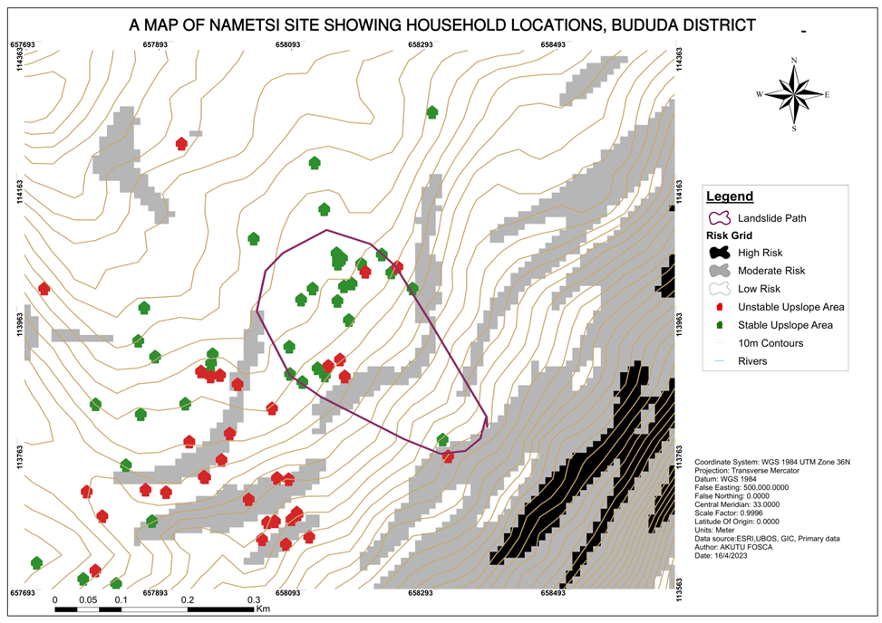
Notes: Figure shows a 1km-by-1km cutout of the Nametsi landslide site. Land surface is shaded to indicate soil instability at each grid point, with darker shading indicating greater risk. Each house icon is the pre-landslide location of a household in our sample. Green indicates a low risk of upslope soil instability; red indicates a high risk. The purple polygon shows the exact landslide path.
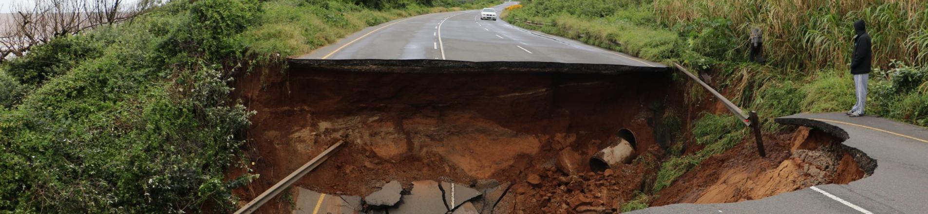
The landslides were devastating and assistance was limited
The landslides caused severe damage. Among households in a landslide path, 28% reported casualties, almost all of which were deaths. Affected households also faced large self-financed repair and reconstruction costs equivalent to around four years of median household income.
The landslides also caused substantial long-term displacement: 68% of affected households were displaced outside their home village, compared with 18% of nearby households outside the landslide path. Nearly all displaced households moved to other rural villages, rather than cities. Among all displaced households, the average duration of displacement was about three years.
External assistance was small relative to need. The median affected household received only about US$31 in aid, roughly 10% of damages, and the government organised only around one-quarter of all displacements. In practice, this meant that many families had to make high-stakes relocation decisions with little support. One-third of displaced households reported that no one else from their original village moved to the same destination.
When we surveyed landslide-affected households 3–12 years after the disasters, we found that they were still substantially worse off. They earned 50% less and were 18 percentage points less likely to say that they were satisfied with their lives. The story was the same across several measures of financial health, mental health, quality of housing, and density of social networks.
The displaced drive much of the harm
Displaced households are central to the story. If we exclude households that left their original villages, the estimated harms become much smaller. That is exactly what many standard surveys would do unintentionally: by surveying only people who remain in the affected area, they would miss many of the households bearing the largest long-run costs.
Figure 2 presents a potentially surprising result: displaced households who return to their original villages seem to fare worse than those who resettle at the destination. In many cases, return looks involuntary. Only about one-third of returnees give a reason for returning that reflects a voluntary choice; the rest move back because they can no longer afford to live in the relocation site or only had temporary arrangements. This suggests that successful resettlement is an important way for displaced households to recover.
Figure 2: Displaced households experienced greater declines in welfare
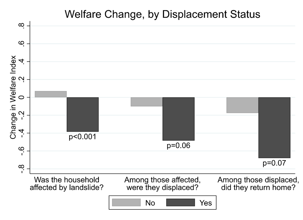
Notes: All households affected by the landslides experienced a decline in their measured welfare, while households that returned to their home village after displacement experienced the largest welfare decline.
Social networks shape recovery
Why did some displaced households resettle and recover better than others? One clue is social capital. Landslide-affected households report significantly fewer close friends in their current village, even years later. Given that social networks help households find work, share risk, and obtain information, it is possible that they also help rebuild after negative shocks.
To study how social networks affected recovery, we compare households displaced along with larger versus smaller groups from their original village. While these decisions are surely not made randomly, we leverage randomness in displaced group size introduced by the extent of landslide damages within each village. We find that larger co-displaced groups were more likely to resettle in the destination and establish non-farm livelihoods.
The point is not that everyone should be forced to move together, but that relocation policy should recognise social networks as productive assets. Destroying a house is not the only way a disaster destroys wealth, as scattering a community can also destroy the informal institutions that help people recover.
Policy implications for disaster relocation
Three points follow for policy.
- Track the people, not just the place. Disaster assessments that focus only on the original location may understate long-run harms.
- Treat social networks as part of resettlement policy. Relocation assistance should make it easier for households to move with people they know, or to settle near origin-village contacts already at the destination. Preserving networks may be especially important when households are relocated to places with limited formal insurance, credit, or job-search institutions.
- Provide enough support for recovery, not just immediate survival. In our setting, aid was small relative to damages. The evidence is suggestive, but households receiving reconstruction aid or government-organised resettlement appear to fare better. This is consistent with the broader point that disasters can push households into persistent losses when they must finance recovery on their own.
The Ugandan government has long considered relocating households living in landslide-prone areas, but many people continue to inhabit risky slopes. Our findings strengthen the case for studying ex-ante relocation policies. They also suggest that when ex-ante relocation is not feasible, ex-post resettlement should be designed around how people actually rebuild livelihoods: not as isolated households, but as members of communities.
References
Baseler, T, and J Hennig (forthcoming), "Disastrous displacement: The long-run impacts of landslides," American Economic Journal: Applied Economics.
Claessens, L, A Knapen, M G Kitutu, J Poesen, and J A Deckers (2007), "Modelling landslide hazard, soil redistribution and sediment yield of landslides on the Ugandan footslopes of Mount Elgon," Geomorphology, 90(1–2): 23–35.
Deryugina, T, L Kawano, and S Levitt (2018), "The economic impact of Hurricane Katrina on its victims: Evidence from individual tax returns," American Economic Journal: Applied Economics, 10(2): 202–233.
Nakamura, E, J Steinsson, and J Sigurdsson (2021), "The gift of moving: Intergenerational consequences of a mobility shock," Review of Economic Studies, 89(3): 1557–1592.
Sacerdote, B (2012), "When the saints go marching out: Long-term outcomes for student evacuees from Hurricanes Katrina and Rita," American Economic Journal: Applied Economics, 4(1): 109–135.