


Drawing on a randomised controlled trial among rice farmers in Nigeria, we introduce a new method for linking village-level interventions with high-resolution earth observation data – which captures spatial variation in how new technologies spread and influence land use. While we find evidence that the adoption of improved fertiliser boosts agricultural productivity, the effects on tree canopy cover depend on the local landscape.
Editor’s note: For a broader synthesis of themes covered in this article, check out Issue 2 of our VoxDevLit on Agricultural Technology in Africa.
One-third of the world's forests have been lost since the advent of agriculture, with half of this loss occurring between 1990 and 2020 (Williams 2003, FAO 2022). In sub-Saharan Africa, 75% of agricultural production growth between 2000 and 2018 came from the expansion of farmland while only 25% came from improving agricultural yields (Jayne and Sanchez 2021). These statistics highlight the ‘triple challenge’ faced by agricultural systems around the world to (1) provide a sufficient and nutritious food supply, (2) support and improve livelihoods, and (3) limit environmental damage, forest and habitat loss, and greenhouse gas emissions.
In Bloem and Lundberg (2025), we study the relationship between agricultural technology adoption and deforestation using data from a randomised control trial (RCT) in Nigeria that promoted the adoption of an improved fertiliser among rice farmers (Liverpool-Tasie et al. 2025). Linking landscape-level earth observation data to an experimental intervention randomised at the village-level presents a practical challenge (Jack and Walker 2024). Common approaches can lead to measurement error, which can generate biased effect estimates if information spills over from treatment to control villages, especially in settings where the intervention involves an information campaign.
To address this challenge, we develop a novel method for evaluating the effects of a cluster-level intervention on spatially explicit, landscape-level outcomes. Using household survey data collected in conjunction with the RCT, we construct a spatially explicit measure of exposure to the experimental intervention that incorporates the possibility of spatial diffusion of information.
Our approach offers a tractable methodology for conducting impact evaluations using earth observation data but, perhaps more importantly, also offers opportunities for far more refined insights into land-use responses to development interventions relative to existing approaches. This approach is generalisable to other settings where researchers are interested in estimating the effects of cluster-level interventions on landscape-level outcomes using earth observation data.
A new approach for linking RCT and earth observation data
In many settings, linking earth observation data with data from an RCT is not straightforward. Our setting is no exception: treatment varies at the village level, and our earth observation data is available at the pixel level. Each pixel is a 30-metre square and thus, as is the case in many experimental settings, the unit of randomisation is different from the landscape-level earth observation unit of analysis.
Geo-spatial diffusion of information and/or marketing treatments represents a complicating factor, as it is difficult to cleanly define boundaries characterising the diffusion of information; diffusion might also be mediated by village-level characteristics (i.e. transportation infrastructure, ecological factors). A common approach is to draw circles around village centroids and aggregate the earth observation data within each circle. This approach can lead to measurement error by either coding untreated areas as treated, or coding treated areas as untreated.
The core challenge in this context is assigning treatment status, or treatment exposure intensity, to land units. In an idealised experimental setting, we would know with certainty if a pixel was treated. In most settings, this is not observable. Like many other household survey instruments conducted in rural areas of low- and middle-income countries, our household survey data includes estimated travel times between the household and agricultural plots. We use this travel time information to construct a spatially explicit measure of treatment exposure at the pixel-level for each treated village. Our approach follows three steps:
- Model distances between households and plots: In our application, we use estimates of travel time between households and measures of agricultural plots, collected at baseline and endline. We find that this travel time data tends to fit a gamma distribution that varies at the village level. In principle, this modelling step could be conducted non-parametrically using the empirical distance distribution. However, this will only generate an in-sample surface with considerably higher computational demands. This step defines the distribution of treatment exposure around each village.
- Define probabilistic measures of pixel-level exposure to treatment: For each pixel, we define a probabilistic measure of treatment exposure based on the village treatment distribution. This generates a series of surfaces that define the probability that each pixel in our study area is exposed to the treatment administered in each of the treatment villages.
- Generate a continuous measure of treatment exposure: This final step simply sums over each of the surfaces for each pixel to create a single and continuous measure of exposure to the village-level treatment.
Figure 1 illustrates the spatial distribution of this continuous treatment exposure measure within 15 kilometres of the village centroid within each village in our study. The measure ranges with value between zero (indicating no exposure to the treatment) and three (indicating exposure to the treatment from multiple villages).
Figure 1: Continuous treatment exposure surface
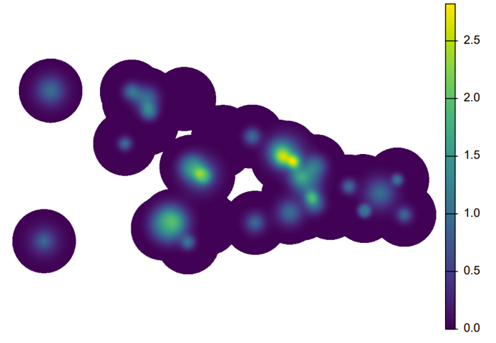
Notes: This figure is taken directly from Panel (b) in Figure 3 in Bloem and Lundberg (2025).
Identifying an intensification response to agricultural technology
The way the adoption of improved agricultural technologies can affect deforestation is theoretically ambiguous. Improved agricultural technologies can increase the relative value of agricultural land and induce farmers to expand their farms into forested lands. On the contrary, adopting new and improved agricultural technologies could alternatively lead to an intensification response ultimately easing land conversion pressures on nearby forests.
Figure 2 illustrates this heterogeneous relationship by plotting the change in canopy cover loss driven by exposure to the intervention based on the level of pre-existing (i.e. baseline) tree canopy cover density – measured as the percent of baseline tree canopy cover. These results show that land with less than 20% baseline tree canopy cover tends to see the loss rate increase in response to the intervention, while land with greater than 20% baseline tree canopy cover tends to see a reduction in the canopy loss rate.
Figure 2: Reduced deforestation in more dense forest areas
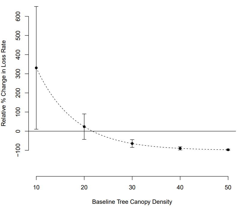
Notes: This figure is taken directly from Figure 5 in Bloem and Lundberg (2025).
While previous research conducts analysis at the cluster (village) level, we conduct our analysis at the landscape level, i.e. spatially explicit grid cells or pixels. This is useful for at least four reasons:
- Village-level analysis can be under-powered, leading to limitations related to statistical inference.
- Conducting analysis at the pixel level allows us to construct a spatially explicit and continuous measure of exposure to the experimental intervention based on the proximity of a pixel to one or more treatment village centroids.
- Pixel-level analysis enables an assessment of granular landscape-level heterogeneity.
- Common approaches used to aggregate landscape-level data to match cluster-level interventions can lead to biased effect estimates if information diffuses geo-spatially and spills over between treatment and control villages. This is an important methodological contribution, especially in settings (such as ours) where the agricultural technology in question could plausibly lead to an intensification response indicated by granular landscape-level heterogeneous effects.
Policy implications: Deforestation
We merge earth observation data on forest cover with household survey data and estimate rates of tree canopy cover change in areas exposed to the intervention. We find that results vary significantly by baseline levels of canopy cover. In areas with less dense canopy cover, exposure to the intervention increases tree canopy loss. By contrast, in areas with more dense canopy cover, exposure decreases tree canopy loss. We also document positive productivity effects in areas exposed to the intervention.
These results indicate an intensification response to the intervention that depends on landscape characteristics. Our spatially explicit approach allows us to identify this varying intensification response that might otherwise be obscured in more aggregated analyses. Indeed, on average, we find no difference in canopy loss in areas more exposed to the intervention relative to areas less exposed to the intervention.
Environmentally friendly agricultural technologies that improve productivity while reducing environmental externalities represent a feasible approach to address the ‘triple challenge’ of producing a reliable food supply, supporting livelihoods, and limiting environmental damage. More generally, agricultural research and efforts to promote the adoption of improved technologies may be an efficient and effective way to sustainably support both nature and people around the world.
References
Bloem, J R, and C Lundberg (2025), “Agricultural technology adoption and deforestation: Evidence from a randomized control trial,” Journal of Development Economics [forthcoming].
FAO (2022), “The state of the world’s forests 2022: Forest pathways for green recovery and building inclusive, resilient and sustainable economies.”
Jack, K, and K Walker (2024), “Integrating remote sensing and randomized controlled trials.”
Jayne, T S, and P A Sanchez (2021), “Agricultural productivity must improve in sub-Saharan Africa,” Science 372: 1045–1047.
Liverpool-Tasie, S, A Dillon, J R Bloem, and S Adjognon (2025), “Private sector promotion of agricultural technologies: Experimental evidence from Nigeria,” Journal of Environmental Economics and Management 133: 103201.
Williams, M (2003), “Deforesting the earth: From prehistory to global crisis,” University of Chicago Press.