


Expanding irrigation infrastructure in Senegal led to significant and sustained increases in cultivation rates and reduced sensitivity to temperature shocks.
Editor's note: The authors have made slides available to accompany this research here.
Food security in sub-Saharan Africa remains heavily reliant on an agricultural sector that continues to struggle to achieve high productivity, both in terms of yield levels and stability. Enhancing agricultural productivity is widely recognised as a critical priority, particularly in light of rapidly growing demand driven by population growth, which is projected to reach 3.3 billion in sub-Saharan Africa by the end of the century (UN 2024). At the same time, climate change poses an additional threat to agricultural output and food security in the region (Lobell et al. 2008). In this context, a key strategy for addressing food deficits involves shifting away from dependence on rainfed and flood-recession agriculture towards more widespread adoption of irrigated agriculture (Rosa et al. 2020).
In spite of policy and academic interest, evaluating the role of irrigation infrastructure in most developing countries has proven challenging due to a lack of time series data on land use and agricultural output. In recent research (Cisse et al. forthcoming), we examine the long-term effects of the damming of the Senegal River in the 1980s and subsequent gradual expansion of irrigated land, using a long time-series of satellite imagery.
The Senegal River Valley presents a unique and interesting context. It is the site of one of the few existing large irrigation schemes in sub-Saharan Africa, and runs through the Sahel, a region highly exposed to climate shocks. It also has sparse background vegetation, which facilitates the detection of cultivated land via satellite imagery. Satellite imagery offers two key advantages: it provides high-frequency coverage and captures farms of all sizes, including large commercial units. In contrast, household surveys such as the LSMS-ISA are limited to household-operated farms and are conducted infrequently (Wollburg et al. 2024).
A satellite measure of cultivation rates
To overcome the data limitations required to study the impact of irrigation, we utilise a dataset of over 3,000 publicly available Landsat images collected between 1985 and 2019. To transform the imagery into data suitable for analysing agricultural outcomes, we compute the normalised difference vegetation index (NDVI) for each 30m x 30m pixel and apply a simple algorithm to classify pixels as cultivated or uncultivated each agricultural season. We combine this newly developed dataset on cultivated land with administrative data from the Senegalese government covering 871 distinct irrigation infrastructure projects completed between 1988 and 2019. Merging these data sources yields a panel dataset tracking seasonal cultivation rates over more than three decades covering 1,364 distinct productive units. This allows us to dynamically trace out the effects of irrigation infrastructure over time and by year of completion for these explicitly demarcated irrigation perimeters.
Irrigation infrastructure leads to sustained increases in cultivation and reduces sensitivity to temperature shocks
We estimate the effect of the irrigation projects on cultivation rates using a recently developed event study method (Borusyak et al. 2024), exploiting the staggered rollout of irrigation projects.
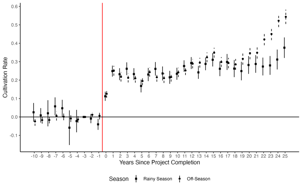
Cultivation rates increase substantially beginning in the first year after irrigation infrastructure completion. The effects are remarkably stable at around 25 percentage points higher in the irrigated development units for the first 20 years. This represents a seven-fold increase from 4 to 29 percentage points in the non-rainy season, and a tripling from 10 to 35 percentage points cultivated in the rainy season (Figure 1). More than 20 years after the irrigation project started, the estimated effects continue to rise, particularly during the (dry) off-season, with cultivation rates exceeding pre-irrigation levels by more than 50 percentage points. These effects are sizable, suggesting that off-season cultivation rates increased by nearly an order of magnitude 25 years after project completion. Overall, we find that impacts on cultivation rates are large and sustained.
Figure 1: Effect of irrigation project completion on cultivation rate
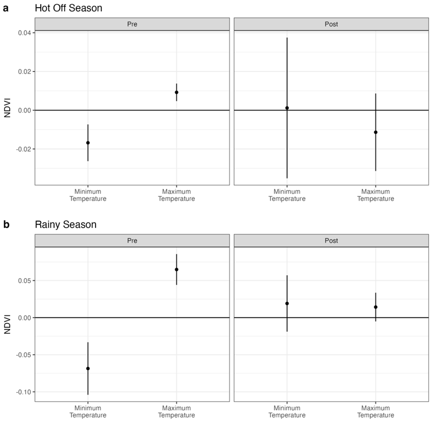
To examine the role of irrigation in facilitating climate adaptation, we estimate the effects of seasonal averages of daily minimum and maximum temperatures on NDVI, both before and after the completion of irrigation projects. Figure 2 shows that, prior to irrigation, minimum and maximum temperatures have significant and opposing effects on NDVI, consistent with previous research on temperature sensitivity in rice production (Welch et al. 2010). However, these effects largely dissipate after irrigation is introduced. This pattern suggests that, in addition to increasing overall cultivation, irrigation substantially reduces vulnerability to temperature shocks – an important channel through which irrigation contributes to climate resilience.
Figure 2: Effects of temperature by presence of irrigation
There is a considerable variation in cultivation rates across farms
Despite the large average increases in cultivation rates following the development of an irrigation project, we observe a wide variety of development unit trajectories, ranging from instant success to almost complete disuse. Indeed, the majority (54%) of development units either utilise less than a third of their serviced area on average (18%), or exhibit large average interannual swings of 10 percentage points or more in cultivated land share (36%). This latter ‘intermittent use’ trajectory constitutes the single most prevalent pattern of land use we observe after irrigation project completion, both in terms of area serviced and in the absolute number of development units, suggesting that irrigation utilisation remains meaningfully constrained (Jones et al. 2022).
Water constraints are a key barrier to continuous cultivation
While satellite data can reveal whether land is cultivated, it does not provide information on the reasons for non-cultivation. To address this gap, we conducted a dedicated survey targeting farmers identified within their communities as having parcels that were either intermittently cultivated or left continuously uncultivated. These surveys reveal that, in spite of all plots in the sample being in projects with completed irrigation infrastructure, farmers cite lack of water availability as the main constraint to land cultivation. This is the case for 61.6% of continuously unused land and 34.7% of intermittently used land. The second most important cause for lack of utilisation is financial constraints, especially among intermittently used plots.
Implications for agricultural policy
First, the use of satellite data highlights the significant extent of intermittent land use – a pattern that has received little attention to date. This is likely because identifying such dynamics requires high-frequency observations of the same plots, something that low-frequency farmer surveys cannot easily capture.
Second, while policy discussions often emphasise expanding irrigated areas, our combined use of satellite imagery and survey data underscores the critical role of maintaining and repairing existing irrigation infrastructure to address persistent water access problems and thereby raise cultivation rates. Likewise, expanding access to modern financial services – such as credit, crop insurance, and index insurance – offers a potentially important pathway to reduce underutilisation of irrigated farmland. Ensuring that existing cropland is effectively utilised is crucial to meeting food security and sustainability goals, given the large contribution of agricultural land expansion to greenhouse gas emissions (Barrett et al. 2023).
References
Barrett, C B, A Ortiz-Bobea, and T Pham (2023), “Structural transformation, agriculture, climate, and the environment,” Review of Environmental Economics and Policy 17(2): 195–216.
Borusyak, K, X Jaravel, and J Spiess (2024), “Revisiting event study designs: Robust and efficient estimation,” Review of Economic Studies 91(6): 3253–3285.
Cisse, A, A de Janvry, J Ferguson, M Gonzalez-Navarro, S Mbaye, E Sadoulet, and M Syll (2026), “Irrigation infrastructure and satellite-measured land cultivation impacts: Evidence from the Senegal river valley,” Journal of Development Economics: 103615 [forthcoming].
Jones, M, F Kondylis, J Loeser, and J Magruder (2022), “Factor market failures and the adoption of irrigation in Rwanda,” American Economic Review 112(7): 2316–2352.
Lobell, D, M Burke, C Tebaldi, M Mastrandrea, W Falcon, and R Naylor (2008), “Prioritizing climate change adaptation needs for food security in 2030,” Science 319(5863): 607–610.
Rosa, L, D Chiarelli, M Sangiorgio, A Beltran-Peña, M Rulli, P D’Odorico, and I Fung (2020), “Potential for sustainable irrigation expansion in a 3°C warmer climate,” Proceedings of the National Academy of Sciences 117(47): 29526–29534.
UN (2024), “World population prospects 2024: Summary of results.”
Welch, J, J Vincent, M Auffhammer, P Moya, A Dobermann, and D Dawe (2010), “Rice yields in tropical/subtropical Asia exhibit large but opposing sensitivities to minimum and maximum temperatures,” Proceedings of the National Academy of Sciences 107(33): 14562–14567.
Wollburg, P, T Bentze, Y Lu, C Udry, and D Gollin (2024), “Crop yields fail to rise in smallholder farming systems in Sub-Saharan Africa,” Proceedings of the National Academy of Sciences 121(21): e2312519121.