


Experimental results find that formalisation of customary landholdings and land rights reduced tree cover loss in rural areas of Benin
Rising demand for agricultural land is a major driver of deforestation, contributing to biodiversity loss and climate change (Curtis et al. 2018, Barlow et al. 2018). A range of actors have long argued that securing the property rights of local populations and improving commons management may help protect forests (Ostrom 1999, Bodin 2017). Indeed, a recent ‘Global Call to Action’ backed by more than 300 organisations, argued that “insecure land rights are a global crisis … undermining our ability to confront climate change” (Pearce 2016). Conservationists have typically concentrated on tenure interventions focused on forests, such as the creation of protected areas. Yet, the ability of protected areas to preserve forests is limited (Pouzols et al. 2014, Watson et al. 2014) and there can be important trade-offs between conserving ecosystems in this way and improving living standards and economic prosperity (Frank and Schlenker 2016). Indeed, while many low-income countries have implemented programmes to improve rural land governance, they have often focused on improving the security of agricultural land (Byamugisha 2013). The impact on forests of such an approach is, however, very uncertain (Baland and Platteau 2000, Robinson et al. 2018). A few studies have evaluated the impact of agricultural land rights security on deforestation, mostly in South America and Southeast Asia, and have found conflicting results depending on the context and characteristics of landholders (e.g. Probst et al. 2020).
A programme to register land rights in Benin
Benin has one of the highest deforestation rates in the world, having lost approximately a quarter of its forested area between 1990 and 2015 (FAO 2015). The main cause of this deforestation is agricultural expansion (Curtis et al. 2018, Bidou et al. 2019). In 2009, the government of Benin rolled out an experimental scale-up of the Plans Fonciers Ruraux (PFR) programme with the objective of both increasing agricultural production and protecting natural resources. The programme demarcated landholdings within villages, documented usage rights, and created institutions to facilitate conflict resolution.
While most of the landholdings demarcated by the PFR programme comprised of agricultural plots, forested areas were also demarcated in several ways. At times, areas of communally managed forest were documented explicitly in the PFR – as an example, Figure 1(a) shows a demarcated area with some tree cover explicitly labelled as a “domaine sacré” (sacred ground) within the PFR. Areas of forest also frequently occur on areas registered in an individual’s name, such as those in Figure 1(b), though even here the individual is typically described as a representative of a lineage or “collectivité”. Even when forested areas are not included within the PFR, they may be effectively demarcated by the programme. For instance, Figure 1(c) shows a small forest which is encircled by demarcated landholdings, while Figure 1(d) displays an area of forest that lies between two demarcated villages. Overall, therefore, the PFR programme effectively demarcated many forested areas in addition to agricultural plots.
Figure 1 Examples of forested areas demarcated by PFRs
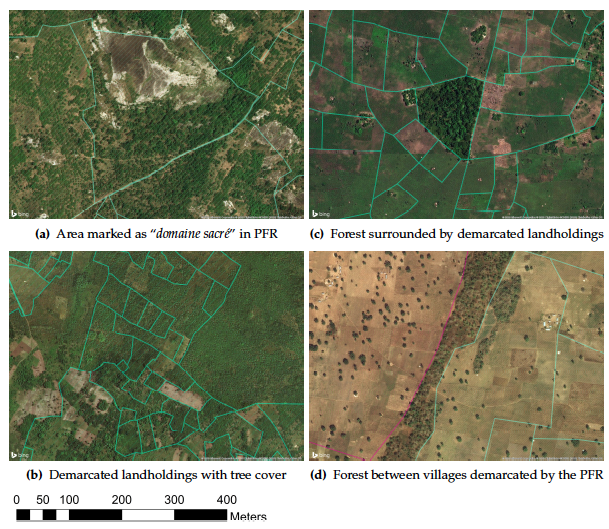
Notes: This figure gives examples of areas containing tree cover that have been effectively demarcated by PFRs. Satellite images are from Bing Maps Aerial. Hatched areas correspond to demarcated landholdings with entries labelled within the village PFR, and solid lines display the recorded borders of these landholdings. In image (d), the two colors represent two adjacent treated villages.
Photo credit: Microsoft Bing Maps Aerial.
The impact of the PFR programme on tree cover loss
In a recent paper (Wren-Lewis et al. 2020), we evaluated the impact of the randomised rollout of the PFR programme across the country on forest cover. The rollout selected 575 eligible villages and then organised 80 lotteries to randomly pick 300 treatment villages. Activities began in these villages in 2009, and to this date the programme has not been expanded to the control villages.
We measured the impact on forest loss using three different sources:
- Our primary measure is from a publicly available dataset of global annual forest loss between 2000 and 2017, constructed by Hansen et al. from Landsat satellites.
- We also constructed our own measure of forest loss from 2010 using higher resolution data from RapidEye satellites.
- Finally, we analysed the impact on fires measured by MODIS satellites, since fires are commonly used to clear land in Benin. To reduce loss of precision due to measurement errors of each outcome, we also looked at a composite index of the three indicators.
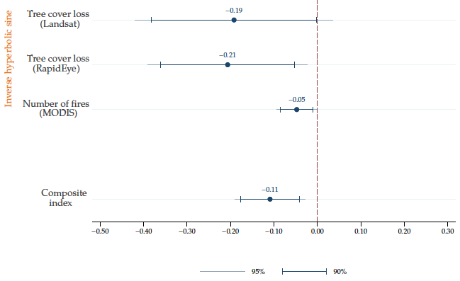
Figure 2 summarises the main findings of our work. Our estimates suggest a reduction in tree cover loss of around 20% and a reduction in fires of 5% in the areas containing treated villages. Using the Landsat measure, we estimate that the programme helped avoid 600 Ha of extra tree cover loss by the end of 2017.
Figure 2 Average effect of selection into PFR on tree cover loss and forest fire
A potential concern is that the measured reduction in tree cover loss could be the result of a displacement rather than a net reduction. This could occur in two ways:
- Tree cover loss may be displaced over time if villagers anticipate the formalisation and clear land beforehand.
- Tree cover loss may be displaced geographically if the programme makes it relatively harder to clear trees in the treated village. In our analysis, we carried out several tests for both kinds of displacement; overall, we found no evidence for either type of spillover. Therefore, if spillovers did indeed occur, they are unlikely to have been on some scale as the main direct effect we estimate.
What explains the reduction in tree cover loss?
Evidence from the pattern of tree cover loss and survey data (presented in Figure 3) suggest three likely mechanisms through which the PFR programme reduced tree cover loss:
- The programme may have increased farmers’ investments in existing plots, increasing productivity, and hence, reducing the need to clear further land. This is supported by the results of two other studies which found that the programme led to increased investment (Goldstein et al. 2018, Yemadje et al. 2014). Consistent with this, we find that community leaders in treated villages are significantly less likely to report land clearing, and that there is a significant reduction in tree cover loss directly adjacent to agricultural plots.
- The increase in tenure security may have guaranteed farmers that their claims to forested land were secure, and hence reduced their incentive to safeguard such land through clearing. Indeed, treated villages are significantly less likely to experience border conflicts, which is corroborated in our qualitative survey, where one interviewee responded that “since the project placed markers, everybody knows their parcels and there are no more land problems”.
- The delimitation of landholdings and creation of local land committees is likely to have eased commons management. Treated villages reported a significantly higher level of trust in institutions to resolve land conflicts and were significantly more likely to say that communal areas were managed by a local committee such as the ‘conseil du village’, rather than an individual. This is consistent with the PFR programme’s stated aim of encouraging participation in land governance. Treated villages are also significantly more likely to restrict access to communal forests than control villages.
Figure 3 Average effect of PFR on disputes, norms and local land management
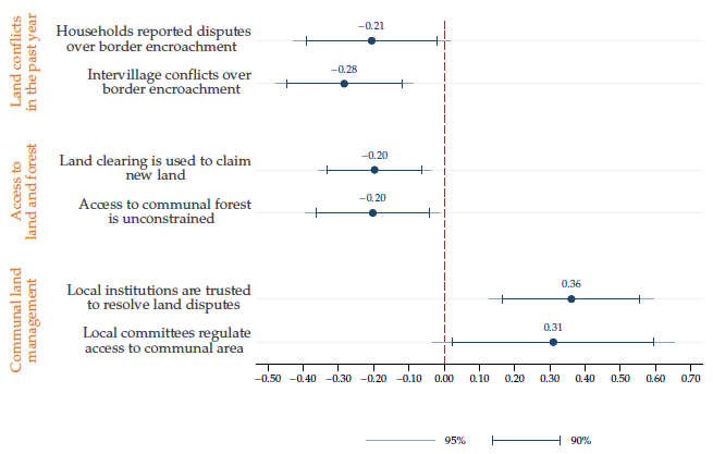
Note: The outcome variables represented in this figure were standardised. This helps compare the effect sizes across variables as variation in units of standard deviation.
Discussion
Curbing deforestation is a major environmental challenge, and addressing it requires assessing the effectiveness of a range of policies and understanding the mechanisms behind their successes or failures. Evidence from the PFR programme in Benin suggests that land formalisation programmes focused on agricultural land can generate an important positive externality in reducing forest loss. We cannot, however, directly infer the extent to which the results are generalisable, and more studies are therefore required to identify how deforestation impacts will vary in other contexts.
Since deforestation trends are driven by several factors and there is likely no silver bullet to address them all, policymakers should adopt several approaches depending on local contexts. In this sense, land formalisation may be an important complement to other programmes which have been shown to be effective elsewhere, such as payments for ecosystem services (Jayachandran et al. 2017). Programmes such as these often rely on defining who is responsible for the management of a given forest, and therefore implicitly formalise a system of rights. In this context, it is important to have evidence on the direct impact of the formalisation process on deforestation.
References
Baland, J M and J P Platteau (2000), Halting degradation of natural resources: Is there a role for rural communities? Oxford University Press.
Barlow, J, F França and T A Gardner (2018), "The future of hyperdiverse tropical ecosystems”, Nature 559, 517–526.
Bidou, J E, I Droy, R Houesse and C Mering (2019), “Dynamiques démographiques, vulnérabilité et évolution du couvert végétal au nord Bénin: des interactions complexes", Espace. Popul. Soc. 2018.
Bodin, Ö (2017), “Collaborative environmental governance: achieving collective action in social-ecological systems”, Science 357.
Byamugisha, F F K (2013), “Securing Africa's land for shared prosperity”, World Bank, Washington DC.
Curtis, P G, C M Slay, N L Harris, A Tyukavina and M C Hansen (2018), “Classifying drivers of global forest loss”, Science 361, 1108–1111.
FAO (2015), “Global Forest Resources Assessment 2015: How are the world's forests changing?”, FAO, Rome.
Frank, E G and W Schlenker (2016), “Balancing economic and ecological goals”, Science 353, 651–652 (2016).
Goldstein, M, K Houngbedji, F Kondylis, M O'Sullivan, H Selod (2018), “Formalization without certification? Experimental evidence on property rights and investment”, Journal of Development Economics 132, 57–74 (2018).
Jayachandran, S, J De Laat, E F Lambin, C Y Stanton, R Audy and N E Thomas (2017), “Cash for carbon: A randomized trial of payments for ecosystem services to reduce deforestation”, Science 357, 267–273 (2017).
Ostrom, E (1999), “Self-governance and forest resources”, CIFOR Occ. Paper 20.
Pearce, F (2016), “Common Ground: Securing land rights and safeguarding the earth”, Oxfam International, Oxford.
Pouzols, F M, T Toivonen and E D Minin (2014), “Global protected area expansion is compromised by projected land-use and parochialism”, Nature 516, 383–386 (2014).
Probst, B, A BenYishay, A Kontoleon and T NP dos Reis (2020), "Impacts of a large-scale titling initiative on deforestation in the Brazilian Amazon", Nature Sustainability, 1-8.
Robinson, B E, Y J Masuda, A Kelly, M B Holland, C Bedford, M Childress, D Fletschner, E T Game, C Ginsburg, T Hilhorst and S Lawry (2018), “Incorporating Land Tenure Security into Conservation”, Conservation Letters 11, 12383–12383.
Watson, J, N Dudley and D Segan (2014), “The performance and potential of protected areas”, Nature 515, 67–73 (2014).
Wren-Lewis, L, L Becerra-Valbuena and K Houngbedji (2020), "Formalizing land rights can reduce forest loss: Experimental evidence from Benin", Science Advances 6(26): p.eabb6914.
Yemadje, R H (2014), “Revisiting land reform: land rights, access, and soil fertility management on the Adja Plateau in Benin”, International Journal of Agricultural Sustainability 12, 355–369.